
What do we have to fear from the Tonga Volcano?
What do we have to fear from the Tonga Volcano?
Could it be global climate change?

Three months ago, a video of a boiling swimming pool stunned the world. Pyroclastic lava from the Cumbre Vieja volcano, in the Canary islands, slowly turned the blue water into steam as hot magma engulfed everthing on its way. The pool vanished, in an instant, in the 57 seconds video. On 13th December 2021, the fire finally died. As volcanic ash settled, breathtaking and heartbreaking pictures emerged. The Cumbre Vieja volcano, which last erupted 50 years ago, showed the power the nature wields. As I write this piece, an earthquake of 6.2 magnitude rocked the Kingdom of Tonga; its epicentre lies in the northwest of Lifuka island. The Earth’s cauldron is still rumbling. What do we have to fear from the colossal Tonga volcano?
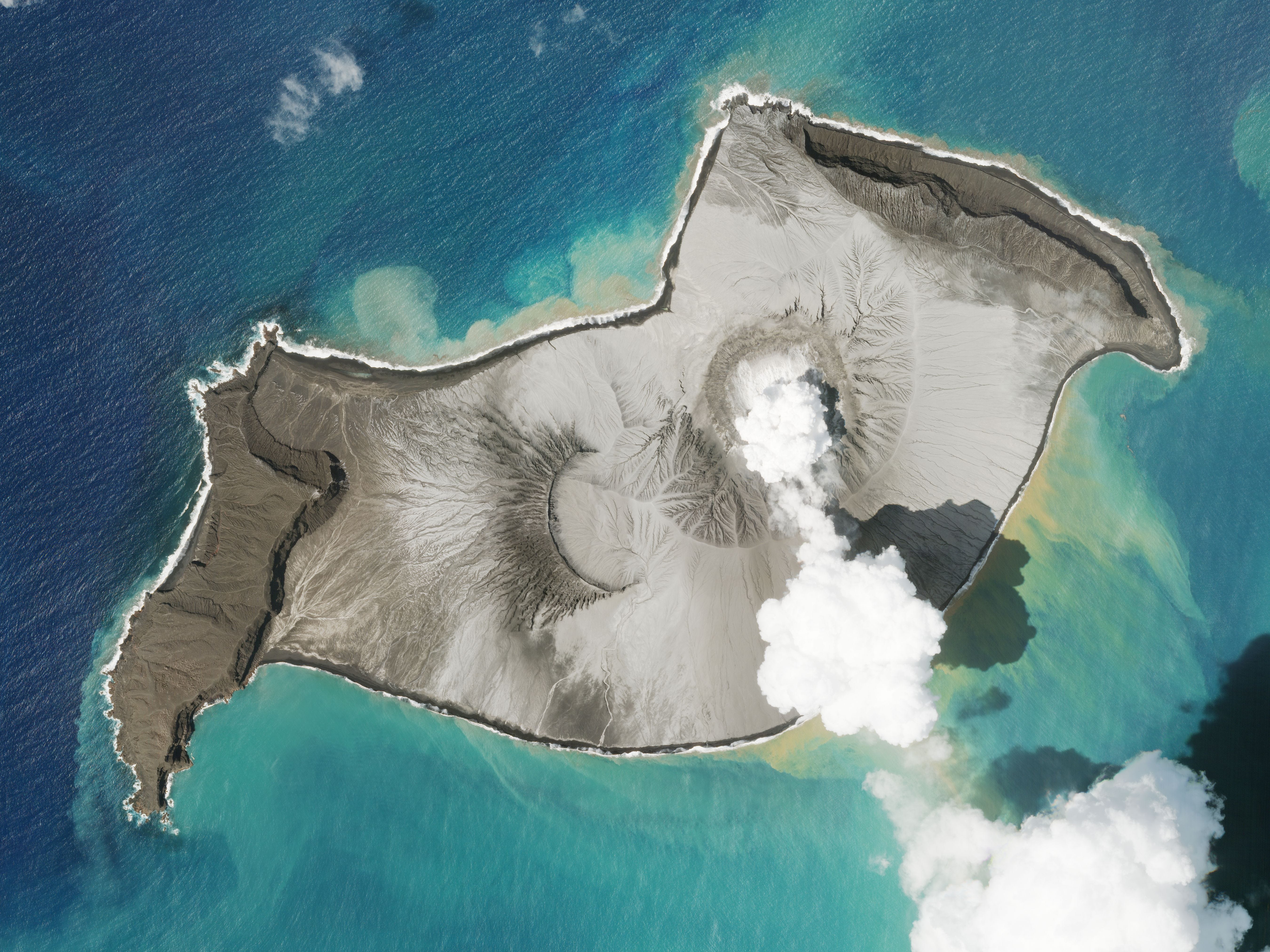
Study the image carefully. What do you see? A scenic image of white smoke rising from an orifice, surrounded by the turquoise-blue water, isn’t it? This is a satellite image of the Hunga-Tonga Hunga-Ha’apai, a submarine volcano, photographed on 7th January 2022. The white smoke is actually steam, as heat from an earlier eruption vaporizes when it comes into contact with the cold water at the crater lake. But there is more to the image than meets the eye. The picturesque water hides an enormous volcanic mountain inside it. What we see is just the mouth of the 4 km wide caldera–a large part of which is underwater for almost 150 m–and the twin islands of Hunga-Tonga and Hunga-Ha’apai.
The Hunga-Tonga Hunga-Ha’apai volcano lies in the critical Kermadec-Tonga subduction zone. A subduction zone is something that forms when two lithospheric plates collide. The denser oceanic plate goes under a continental plate and sinks into the mantle. Here, the oceanic is the Pacific plate and the continental one is the Indo-Australian plate. One may wonder why it doesn’t happen between two continental plates? It does happen but none of the two sinks. When the two plates collide, it gives rise to a new feature. A prime example of this is the Himalayas. Subduction zones are known for frequent earthquakes (due to constant friction between two plates) and tsunamis (most subduction zones are on the coastline). The most notable volcanic mountains that lie in this zone are Mount Krakatoa (1883, 2018) and Mount Tambora (1815).
Formation and destruction of the islands
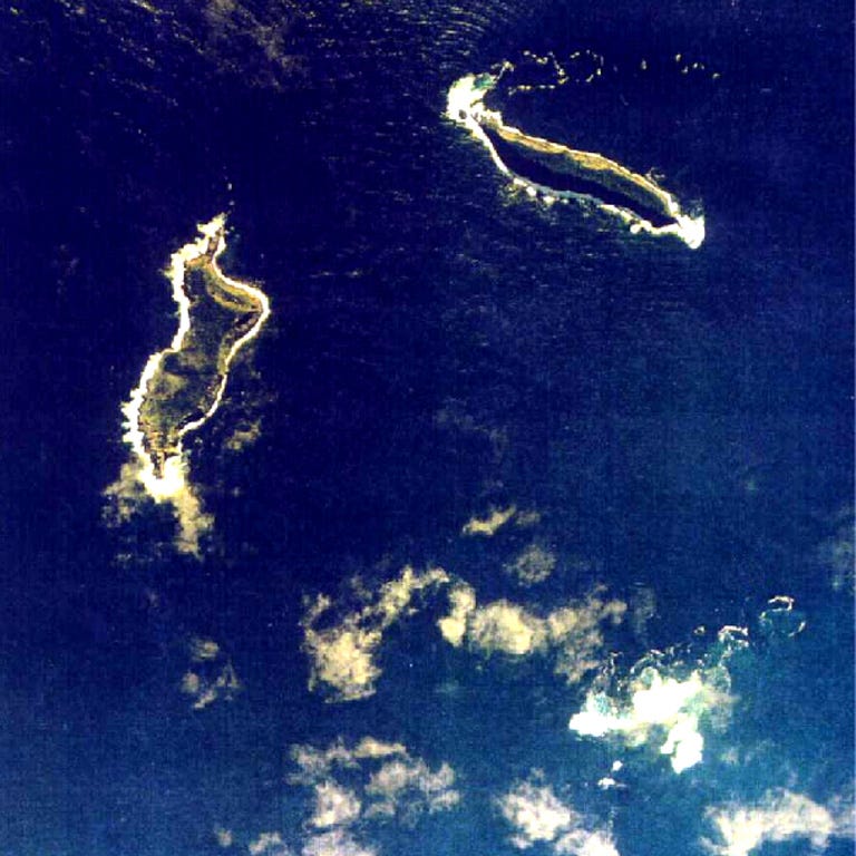
If you refer to the above image, you’d notice there are two distinct islands, both uninhabited: Hunga-Ha’apai (left) and Hunga-Tonga (right). These are 20 km wide islands that sit on the rim of an underwater caldera (or, simply, the mouth of the volcano). The January 2015 eruption wasn’t as deadly as the recent one, but the volcanic tephra from it reached an altitude of 7 km from sea level. Ash and magma deposition was later found out to have helped in forming a connecting island, with a diameter of around 2 km, between the Hunga-Ha’apai and Hunga-Tonga islands. The magnitude of the January 2022 ‘Surtseyan’ eruption was of such intensity that it blew up the connecting island and turned back the clock to a pre-2015 era. For James Garwin, a planetary scientist from NASA, the intensity of the eruption would be anywhere between 4-18 megatons of TNT. Volcanic Eruption Intensity for the eruption is yet to be affixed but could be anywhere between VEI 5-6.

Volcanic debris and Global Climate Change
Before we delve into the topic, it’s important to note what’s special about the Hunga-Tonga Hunga-Ha’apai volcano. What few reports fail to mention is that this submarine volcano started with a Surtseyan-style eruption that instantaneously turn into a Plinian-style. A Surtseyan eruption is generally associated with those where hot magma comes into contact with cold water and produces a spectacular scenery of devastation. But not all Surtseyan becomes a Plinian. Named after the Pliny the younger, who was an eyewitness to Mount Vesuvius eruption and wrote an account of it, Plinian eruptions are devastatingly explosive and can reach an altitude of 50 km into the atmosphere, with the main column of hot gases and pyroclastic debris that takes the shape of an umbrella. Most of these explosions are followed by an extravagant display of lightning strikes. Between January 14th-15th, a total of 40,000 lightning struck Hunga-Tonga Hunga-Ha’apai when the explosion started, which was followed by crescent-shaped shockwaves that circumnavigated the Earth–twice. Pressure change was observed in all the places, most notably in Alaska (sound of the explosion was heard here, 10,000 km from Tonga), Florida, Miami, Cape Town, and Chennai.
Right now, as data slowly emerges, we are still clueless on certain statistics, like the ejected volume of tephra. For now, we know, according to Brian Toon of the University of Colorado, 0.4 Tg of sulphur dioxide was found in the aftermath of the eruption. The threshold limit of the climate sits around 5 Tg.
What do we mean by this number? Let’s discuss.
Sulphur Dioxide
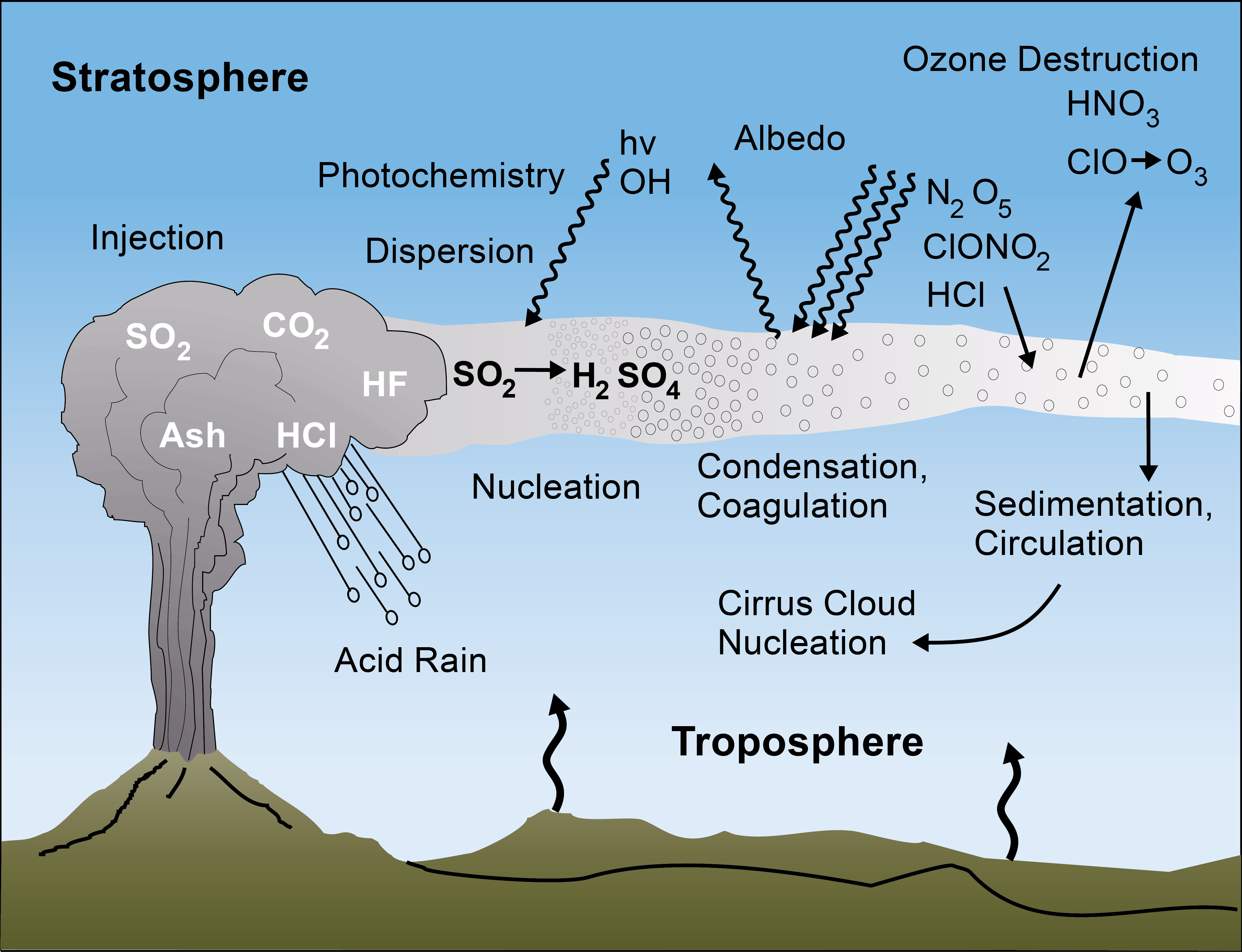
The most important constituent of volcanic gases is sulphur dioxide. For example, in the Mount Pinatubo eruption, one of the deadliest of the 20th century, 15 million tons of sulphur dioxide with volcanic tephra of 5 cubic kilometres were released. The column of the exploded pyroclastic matter reached an altitude of 25 km into the stratosphere. There, sulphur dioxide converts into sulphur aerosols when it comes into contact with water droplets. These aerosols contain 76% of sulphuric acid that falls on earth as ‘acid rain’.
The other aspect is the aerosol dispersal in the stratosphere. This layer is devoid of rain-bearing clouds, which is why the pollutant aerosols sustain for longer periods (1-4 years) and travel far longer distances. Compared to the stratosphere, aerosols in the troposphere can only sustain for 1-3 weeks. These particles can diffract and absorb solar radiation (measured as aerosol optical depth) like a heat shield, which results in a cooling effect on the Earth. In the aftermath of the June 15th, 1991 eruption, the global temperature dropped by around 0.6 degrees Celsius in the next 16 months. Also, due to the absorption of sunlight radiation, the temperature in the lower stratosphere increases, while in the troposphere, it decreases.
Concerning the Tonga volcano, we don’t have the numbers on how much tephra was ejected during the simultaneous eruptions in those two days. But what we do know is that pyroclastic debris blasted from the caldera went up to a height of 40 km–and that is an insane distance.
Tsunami
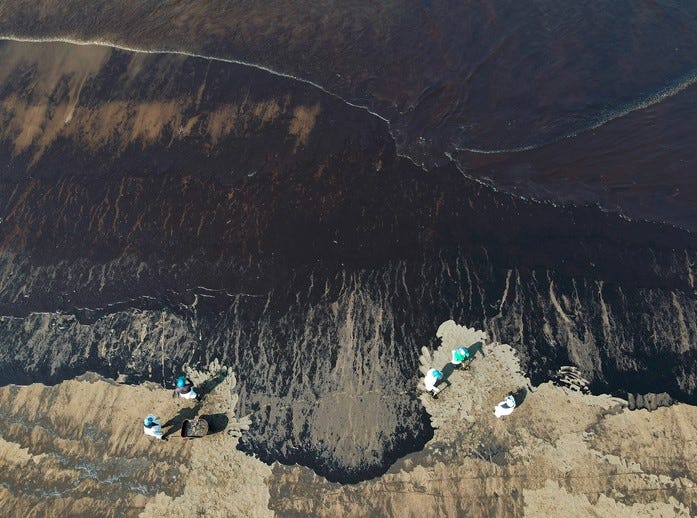
On January 16th, a day after the eruption, news of a massive oil spill in Peru started to spread like a wildfire. As details of the accident slowly emerged, it was found that Tsunami waves, triggered by the underwater eruption, hit ‘Mare Doricum’, an Italian vessel that was filling oil at the La Pampilla refinery, 10,000 km from Tonga, and knocked over approximately 12,000 barrels of crude oil into the ocean. Throughout this, there was no Tsunami warning by the Peruvian Navy. The catastrophe damaged a 38-km-stretch of beach in Chancay and 1.2 million square metres of ocean. With La Niña slowly peeling off, the fishing industry of both, Peru and Tonga, will be severely affected. By the time the tsunami reached Peru, ferocious waves, 2 m in height, had already flattened the islands that were near the epicentre of the eruption.

Carbon Dioxide
The greenhouse gas is the second most important constituent of all volcanic gases–and the most blamed one for global climate change. The hypothesis that CO2 from a rare cataclysm like a volcanic eruption can cause an increase in global temperature has two possible answers. For this, we need to look at an example. During the Mount Pinatubo eruption, approximately 0.05 billion metric tons of CO2 was released. If we compare this data with the global emissions of anthropogenic CO2 in 2020 (which was lowest in the last eight years), 700 of such eruptions would be needed to equal the amount. In 2021, until November, the anthropogenic release of carbon dioxide stood at 35.71 billion metric tons. There had been instances in the global past where massive emissions of carbon dioxide had a considerable effect on the climate, but it is without a doubt that anthropogenic CO2 release exceeds any volcanic CO2 emissions.
Challenges
Tonga has a 7,00,000 square km of special economic zone, which is around 1000 times larger than their own country. The people are heavily dependent on the ocean and tourism, apart from the minimal agriculture they produce. The kingdom, which sits amid scenic beauty, has 1500 square km of coral reefs that are now threatened by the eruption. Along with pyroclastic lava, iron, from the debris, poses another massive challenge in damaging these precious corals by forming blue-green algae. The noxious blooms of Cyanobacteria cause life-threatening diseases among the corals. As the water slowly turns toxic, marine life either dies or migrates to a safer haven.
Global climate change has also catalysed the problem of rising sea levels. In Tonga, sea levels have risen 6 mm a year, which is double the global average. As the country sits on the blade of a crucial subduction zone, tsunamis have contributed to rapid coastal erosion. This has irreversibly affected storm surges and rising water levels.

As of now, volcanic ash deposition has subsided, but there is a strong presence of sulphur dioxide in the atmosphere. At the point of publishing this piece, there are no reports of any acid rain in Tonga, but since the debris and toxic gases have punctured into the stratosphere, chances of it can’t be denied. The chances of global cooling are also rare (looking at the prospective figures). As it continues to shape and re-shape the Pacific Rim landscape with its eruptions in 2009, 2015, and 2022, the Hunga-Tonga Hunga-Ha’apai volcano will now remain in the crosshair of the scientific community for years to come.
Wow! Well written and I learnt lots of new things from it. Keep it up